|
|
|
Operational Production of DEMs from ERS tandem Data Marco van der Kooij ( [email protected]).Atlantis Scientific Inc., 20 Colonnade Road, Suite 110, Nepean, Ont., Canada, K2E 7M6; www.atlantis-scientific.com ABSTRACT In 1995 Atlantis became involved in value added services using repeat-pass InSAR data. The joint in-house development of the EarthView commercial off-the-shelf (COTS) software and the evolution of InSAR technology for value added services has been a key component to the success and growth of the services. This evolution included the development of robust innovative tools, methods for prediction of data quality, optimum data selection, project risk mitigation and efficiency improvements. Several new technical approaches have been implemented such as a phase unwrapping technique as well as methods to deal with problems such as temporal decorrelation, atmospheric effects and poor ground control. A strong integration of ancillary data sources such as low resolution DEMs, ground control points and maps has been proven to be of significant importance in an operational environment. ERS tandem data has been the main source of InSAR data and the critical factor in this success. Strong and flexible connections with ESA and data suppliers have been of great value to initiate the introduction of the technology. All these factors combined have contributed to a completion of 60 commercial InSAR projects and the use of 381 ERS, 112 JERS and 32 Radarsat scenes. The services department has grown and evolved to a size of 10-15 employees. INTRODUCTION In the 1970�s the idea of a dual antenna interferometric SAR system was implemented and tested for the first time by Graham [1]. It became clear that this approach had great promise for DEM generation and that the technology if implemented on future spaceborne systems would have some superior characteristics for wide-area mapping. In the 1980�s Goldstein and Zebker [2] introduced the concept of using a repeated SAR acquisition to create a SAR interferogram. This allowed generation of DEMs and deformation maps using existing single antenna spaceborne SAR systems. Research and application development of this technology increased in particular in Europe in the early 90�s with the launch of ERS-1. A dedicated tandem mission of ERS-1 and the newly launched ERS-2 was executed in 1995 and 1996. It created a valuable world-wide database of data with potential for DEM generation. The value of InSAR data lies in the information content of the high spatial frequencies. This is the most significant information required for generating improved DEMs. The challenge is to extract that value and provide it to the user. Although this value is recognized there are certain misconceptions about the use of ERS repeat-pass InSAR technology. Let�s address some of these misconceptions: "Atmospheric effects make accurate DEM generation impossible". In the last 5 years much of the research has focused on the detection of the phenomenon and confirmation of its origin than on systematic investigation of its impact on DEM generation and on finding practical solutions. It appears that several methods can be used to mitigate or reduce the risk of atmospheric effects (data selection from the large archive, the study of quick looks), to detect these effects using ground control points or even to filter these effects by using ground control or low resolution DEMs. "Temporal decorrelation makes accurate DEM generation impossible". Temporal decorrelation is an important problem but it is remarkable that little systematic research has taken place to assess the impact under a wide variety of conditions and determine methods to predict the coherence as a function of basic parameters. Again several methods can be employed to reduce the risk (data selection from the large archive, use of ancillary weather and vegetation information, the use of InSAR quick looks). "The phase unwrapping of the data is often impossible due to low coherence, layover etc". A lot of the research in this area has focused on attempts to create (ideal) solutions for the phase unwrapping problem. No large-scale systematic and statistical analysis of the potential for unwrapping of ERS tandem data has taken place. It is important to realize that the commercial success of a practical phase unwrapping approach depends on the cost for generating a good quality unwrapped phase image. It appears that a combination of a robust unwrapping algorithm and an unwrapping editor is a must for an effective and high quality unwrapping strategy. The cost of the editing procedure can easily be absorbed in the price of the end product. "New ground control is required for accurate DEM generation". Remote sensing professionals often feel that remote sensing technology must replace existing technologies. A much more realistic scenario is that remote sensing technology integrates with existing technology and brings additional value that is worth the extra cost. A typical example of this scenario is DEM generation for mapping purposes. In many countries there is some existing infrastructure that has evolved during the last 50 years. Typically new technologies have entered this field on a regular basis. Dependent on the efficiency of a new technology it contributed in some way to this infrastructure. InSAR DEM technology has some interesting new value that will supplement to the existing mapping infrastructure. Existing sources of ground control will still be necessary to create the DEM product that is required. "DEM generation from InSAR data is a cumbersome and expensive process" This is not true. More traditional methods such as photogrammetry are much more cumbersome and expensive. The cost per square kilometer of InSAR technology is significantly lower and the data volume is lower as well. This increases the opportunity for robust large area mapping. Atlantis Scientific decided to commit itself to providing DEMs from ERS tandem data as a commercial product in 1996. Many factors have contributed to the successful evolution of this product such as:
Figure 1 shows a bar plot of the yearly revenue from commercial DEM products.
Figure 1. Yearly revenue from InSAR DEM projects at Atlantis Scientific in U.S. dollars. The blue bars relate to ERS DEM production, thered bars relate to non-ERS DEM production. This plot does not include commercial deformation mapping projects and other commercial spaceborne and airborne InSAR projects. The following sections give a summary of Atlantis� strategy of DEM generation using ERS tandem data and provide more insights in the risk management, communication, organization, data selection, processing approaches and efficient robust production of high quality DEMs. ATLANTIS� STRATEGY FOR OPERATIONAL DEM PRODUCTION Leads and client expectations Each and every lead coming in from the sales department has to go through a process of data searches, technical and company risk assessments, recommendation and approval. The communication with the client is of critical importance, the client�s expectations have to be assessed accurately and controlled. Internal communication and (approval) procedures have to be detailed but efficient. Due to the large number of small to medium projects, the structure of the DEM production department is strongly project oriented with project managers responsible for searches, project definition, deadlines, deliverables etc. Risk management Several significant risks can be identified such as:
The most important risks to the data quality are temporal decorrelation and atmospheric effects. A number of procedures have evolved to minimize data quality risks. Depending on the project risks some or all of these procedures can be followed:
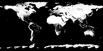
Figure 2. Predicted phase coherence for the month of March.. The coherence ranges from 0.4 black to 0.8 (white). A vegetation model is used to calculate coherence values. A 1 x 1 degree NOAA AVHRR NDVI (Normalized Differential Vegetation Index) mosaic for the month of March (1994) was used to feed this model. The model was empirically derived by fitting a 2nd order polynomial to a scatterplot of average coherence values versus average corresponding NDVI values for 4005 frames of ERS tandem pairs collected over North America.
Figure 3. Predicted phase coherence for the month of September. The coherence ranges from 0.4 black to 0.8 (white). A 1 x 1 degree NDVI mosaic for the month of September (1994) was used
Figure 4. Example of QA points on a DEM generated of ERS data collected in Russell Creek, Yukon (Canada). Colors range from blue to brown indicating differences ranging from +20 to �20 m.
EXAMPLE: ERS DEM OF GOOSE BAY (LABRADOR) Figure 5 shows a DEM created from 25 pairs of ERS tandem data covering an area of approx 150,000 km2 in Labrador (Eastern Canada). The height in the scene varies from sea level to 920 m above sea level. Figure 6 shows a three-dimensional perspective of the section indicated in the white box of figure 5. ERS tandem data was abundantly available. The data selection and processing procedures as described in the previous section was used. The DEM was created by processing 5 segments of raw data using a basic SAR processing system and EarthView InSAR. There are several advantages of processing data in stripmode. The most important advantage is the fact that less ground control is required per square km of SAR data. This makes the ground control point collection and mosaicking process more efficient and reduces the number of seamlines. The vertical ground control consisted of large numbers of airborne survey points with an accuracy ranging from 5-10 m. Horizontal control was derived from 1:50,000 scale topomaps with horizontal accuracy specifications of 25 m. Some of the topomaps were not suitable for ground control point extraction due to limited accuracy specifications (50-100 m). However, the use of (long) strips of SAR data provided some flexibility in the use of ground control. A final quality analysis of 7227 points revealed that the vertical accuracy was 10 m rms (20 m LE) and the horizontal accuracy was approx 25 m rms. These numbers satisfy DTED-2 military specifications. The project duration was 3 months. Four people were involved on a day-by day basis. Figure 5. Color coded presentation of ERS DEM for Goose Bay (Labrador, Canada). The height ranges from 0-920 m. The size of the area is approx. 150,000 km2. The white box shows the area presented in 3-d in figure 6.
Figure 6. Color coded and shaded 3-d presentation of ERS DEM of Goose Bay for the area in the white box of figure 5. The look direction is from NE to SW.
CONCLUSIONS It is possible to create methods of processing, data selection and risk mitigation that allow the practical use of ERS tandem data for operational production of DEMs of high quality in many areas in the world.
Many factors have contributed to successful application of ERS tandem data at Atlantis Scientific including the availability of engineering and applications expertise and the aggressive pursuit of marketing and sales opportunities. The development of dedicated algorithms and evolution of data selection and risk reduction procedures were based on in-house experience with large numbers (approx. 200) of tandem pairs for DEM generation and on the analysis of a large number of ERS tandem quick looks of North America (4000 scenes). ACKNOWLEDGMENTS The ERS InSAR quick-looks of North America were produced by Atlantis under ESA contract No.:12534/97/I-HE. REFERENCES L.C. Graham, "Synthetic interferometer radar for topographic mapping", Proc. IEEE, vol. 62, pp. 763-768, 1974.
|
|
� 2001 Atlantis Scientific Inc. All rights reserved.
|


 H.A. Zebker and R. M. Goldstein, "Topographic mapping from interferometric synthetic aperture radar observations", Radio Sci., vol. 23, no. 4, pp. 713-720, July-Aug, 1988.