|
|
|
Detection and Monitoring of Surface Subsidence Using Synthetic Aperture Radar Interferometry in the Yibal Oilfield, Sultanate of Oman Mark Tuttle (1), Jim Ehrismann(2), Bart Hulshof(2)(1) Petroleum Development Oman LLC, (2)Atlantis Scientific Inc. Summary Petroleum Development Oman LLC (PDO) have successfully employed Synthetic Aperture Radar (SAR) interferometry to detect and measure surface subsidence in the Yibal oil and gas field, Sultanate of Oman. This project was initiated in July 1998, in response to an increased frequency of reported minor earth tremors in the vicinity. The probable cause of reported tremors was presumed to be due to either natural tectonic events, or to localised subsidence resulting from fluid and gas extraction from the sub-surface geologic reservoirs. It is generally understood that the interior of Oman is not a region characterised by tectonic seismicity. ERS tandem mode data was acquired to derive a high resolution digital elevation model for removal of topographic phase effects from subsequent interferometric SAR pairs intended for subsidence modeling. Deformation maps were produced using JERS L-band SAR image pairs acquired in 1995/96, over a time period of 440 days, and RadarSat fine beam SAR image pairs acquired in 1998, over a time period of 120 days. Results of the investigation clearly indicate that surface subsidence is occurring in Yibal, and that the affected area coincides with a particular geologic formation which is currently producing Oman's domestic gas supply. Derived subsidence rates are supported by the results of conventional geodetic measurements, however the effects of tropospheric variations occurring during the SAR acquisition period are suspected to induce significant phase differences between interferometry pairs, which may bias the subsidence model if not adequately compensated. This interactive session discusses procedures, techniques and results, addresses potential sources of error, and suggests directions of further investigation. Background Earth tremors were reported by staff employed at Yibal oil-field since 1996. In late 1997 and early 1998, two tremors were reported which heightened concerns that the phenomena causing the tremors may be accelerating. In July 1998, a project team was established at PDO to determine the cause of earth tremors, predict the amount of reservoir compaction, and prevent potential damage to wells and facilities. The project team was tasked with collection of subsidence and seismicity data, which combined with reservoir engineering would allow the required objectives to be achieved. Experiences from other Shell operated production areas affected by surface subsidence (primarily California, Netherlands, Ekofisk- Norway, Brent-UK) indicate that the impact of subsidence on production operations can be significant. In the case of Ekofisk, offshore production platforms required major structural alterations in order to maintain an acceptable platform-sea surface clearance. Subsidence in the Shell Belridge fields in California is suspected to be the primary cause of multiple well casing failures, resulting in substantial work-over costs. There is very little historical evidence of natural earthquakes occurring in Oman. Two events are known to have happened in the north-eastern coastal area in the 17th century, which led to the destruction of a once-prosperous trading port. A second event in the 1950’s occurred also along the northeastern coast, although this was minor and caused little or no damage. The Yibal oilfield is situated in the central plains of Oman, which are regarded to be tectonically stable. Hydrocarbon production in Yibal occurs in three geologic formations at different depths. The Khuff reservoir is the deepest, and produces very little oil. Pressure in the Shuaiba reservoir is maintained by means of water injection; structural faults in this formation are regarded as very permeable and water conductive, therefore it is unlikely that the injection process causes reactivation due to reduced friction along the fault. The Natih gas reservoir is the shallowest; gas production from this interval is ongoing, and reservoir pressure has decreased from 10120 kPa to 7920 kPa.
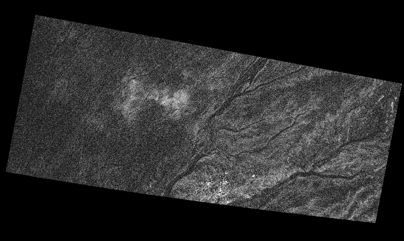
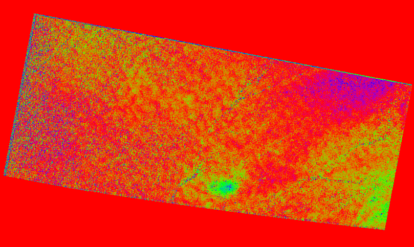
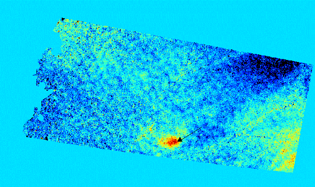
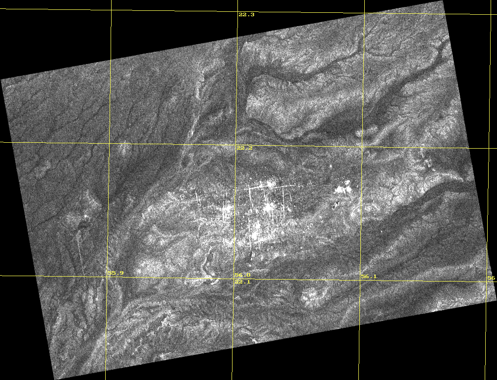
Based on available information, it is likely that the reported tremors in Yibal are caused by the depletion of the Natih gas reservoir. As hydrocarbon reserves are removed, the host formation will undergo compaction, and dormant subsurface faults may be re-activated. Compaction may lead to a reduction of reservoir porosity, which in turn would affect production levels. Reactivation of faults may compromise the integrity of the reservoir seal, resulting in natural migration of hydrocarbons to other formations or to the surface. The Natih reservoir is composed of carbonates with widely varying characteristics. It is divided into seven members, with porosities ranging from 11% to 44%. The reservoir is domal, with NE-SW and NW-SE trending faults. Overlying shale seals the reservoir. Assuming an elastic mechanical model of the reservoir, and pressure depletion of 8000 kPa and compressibility of 2.5e-5 kPa, a maximum compression of 13 cm was calculated. This figure is very conservative, based on the observed compressibility of other carbonate reservoirs. Tandem ERS-1/2 DEM Generation In order to detect surface deformation using interferometry an accurate DEM is required to remove the topographic phase effects. Such a DEM can be created using SAR interferometry. ERS tandem mode data is ideally suited for DEM generation, since the time span between acquisitions is one day. Thus temporal decorrelation is minimized and the likelihood of surface deformation occurring is negligible. One ERS tandem mode pair was used for DEM generation. The ERS-1 SAR backscatter image from one of these scenes is shown in Figure 1. Note the two white bands running approximately horizontally across the image. These indicate missing lines in the raw data. The oil field can be seen in the bottom left quadrant of the scene. The cyan rectangle indicates the extent of the composite image map provided by Petroleum Development Oman. The red and yellow rectangles indicate the processed subsections of the JERS-1 and RADARSAT scenes, respectively. The coherence is shown in Figure 2. Coherence is defined as the complex correlation between the two images of an InSAR pair. Thus it shows the temporal correlation between the two scenes. A coherence level of 1.0 (white in the image) indicates perfect temporal correlation while a coherence level of 0.0 (black) indicates completely decorrelated data. Figure 2 indicates that there is a very high level of correlation between the two ERS scenes. The dark stripes are due to missing data lines in the original raw data. The InSAR derived DEM is shown in Figure 3. The elevation ranges from 60 m (blue) to 370 m (red-brown). JERS-1 Deformation Map Generation The area of interest is located at the southern extent of the JERS-1 scenes but has about 75% coverage (see Figure 1). Figure 4 show the JERS-1 backscatter of the processed subsection of the Jan. 1, 1995 scene. The oilfield can be clearly seen as the only prominent feature. The coherence for the JERS-1 pair is shown in Figure 5. The coherence is quite low compared to the ERS-1/2 result (Figure 2). This is not surprising however since the time between scene acquisitions is nearly 15 months. Typically for JERS-1 interferometry, good phase recovery can be made even for low coherence values. The interferometric phase is shown in Figure 6. Because of the cyclical nature of phase, colour is used to represent it. A value of zero is represented by red and as the phase increases it is represented by smooth transition from red to green to blue and then back to red as it reaches 2p (i.e. one cycle). Independent phase effects, which may be present in such an interferogram, are due to topography, surface change and atmospheric anomalies. Because the baseline of this pair is relatively small (Table 2) for JERS-1 the phase is not highly sensitive to the topography (one cycle of phase corresponds to about 100m in height variation). Since the maximum height variation in the region covered by this JERS-1 subsection is about 40m the contribution to the phase due to topography was considered negligible relative to other effects, such as deformation, in the interferogram. The interferogram shows a predominantly constant phase (with variation due to noise) between red and green. The top right section appears blue while the bottom right section is green. Comparison with the ERS-1/2 DEM reveals that these variations are likely due to topography. There is a significant indication of surface deformation at the study area. A nearly circular phase pattern can be seen in the bottom near the middle of the scene. Considering the baseline for this InSAR pair this pattern cannot be accounted for by the topography known to be present. By unwrapping the phase and applying a straightforward conversion a height change map is produced (Figure 7). Note that this conversion assumes that the phase effect measured is due to height change only (no lateral movement). It is important to recognize that the SAR measures only the component of surface motion along the viewing direction of the SAR. The actual surface motion must be inferred from additional knowledge about the area of interest. In the case of the Yibal oilfield, given the relatively flat topography and the nature of the extraction activities, it is assumed that the surface motion is height change. Also note that a positive valued surface motion measurement (along the viewing direction of the SAR) indicates motion away from the SAR. Thus in terms of height change this positive measurement indicates subsidence. The nearly circular feature that can be clearly seen in Figure 7 is likely due to subsidence. Note that no height change measurements were recovered for the left side of the scene. This was because the phase unwrapping failed due to prohibitively low coherence. In such cases it is sometimes possible to infer and estimate motion measurements from the interferogram directly. RADARSAT Deformation Map Generation The two RADARSAT scenes listed in Table 1 were paired for InSAR processing. They represent a time span of about four months. Figure 8 shows the backscatter of the processed subsection of the Mar. 4 1998 scene. The oilfield can be clearly seen. The coherence for the RADARSAT pair is shown in Figure 9. As with the JERS-1 pair the coherence for the RADARSAT pair is quite low compared to the ERS-1/2 result (Figure 2). Although the time span of the RADARSAT pair is considerably less the coherence is comparable to that of the JERS-1 pair. This is due primarily to the fact that the RADARSAT sensor is more sensitive to temporal decorrelation than JERS-1. RADARSAT employs a shorter wavelength than JERS-1. A unique problem was encountered with processing this RADARSAT pair. It has been noted that there is a sinusoidal anomaly in the RADARSAT satellite positioning, with a period of approximately one year. Thus for a time span of four months the SAR viewing geometry difference for the two scenes is near the maximum. The nature of the phase variation in a SAR data set is dependent on the satellite geometry. If the two data sets (covering the same area on the earth's surface) have different geometries associated with them then there will be differences in the nature of the phase variations. In terms of the frequency spectrum of the phase variation for SAR data what this means is that, although the two scenes will have similar bandwidths, their bandwidths will be centred at different frequencies and thus they do not overlap precisely. When the phases are differenced (to form the interferogram) noise is introduced due to the parts of their bandwidths which do not overlap. As part of the quality analysis of an InSAR pair the spectral overlap is estimated. Normally the spectral overlaps encountered range from 50-90%. This RADARSAT pair exhibited only 25% overlap. The solution to this problem is to filter the data to remove the non-overlapping portions of the two spectrums and then form the interferogram by differencing the phases. The results are demonstrated in Figure 10 for a small section of the RADARSAT interferogram. The improvement is quite noticeable. The mean coherence realized a 50% increase. The phase sensitivity to topography in this data set is approximately 35m per cycle (greater than that for the JERS-1 pair). Also, since the time span is only four months there is likely less surface motion than for the JERS-1 case. Thus the phase effects due to topography were not negligible and were removed using the ERS-1/2 DEM. The resulting differential interferogram is shown in Figure 11. There is considerably more phase information present than for the JERS-1 case. Note that the sample spacing for the RADARSAT data (10m) is twice that of the JERS-1 data (20m). An interferogram such as Figure 11 is difficult to interpret since there appears to be a lot of motion and the phase varies over more than one cycle. Finally, the interferometric phase was unwrapped and converted to a height change map (Figure 12). This is easier to interpret than the interferogram but there are regions where the unwrapping failed due to low coherence. InSAR Measurements The JERS-1 deformation map in Figure 7 reveals a feature typical of subsidence due to subsurface extraction activities. This feature coincides with the northern edge of the developed surface area of the oilfield (compare with Figure 4). Other possible sources of such a feature are topography and atmospheric effects. However the height variation in this area is not significant enough to account for this effect. Due to the longer wavelength of the JERS-1 sensor it is less sensitive to atmospheric anomalies than ERS-1/2 or RADARSAT. A strong atmospheric effect would manifest itself as a small fraction of a cycle of phase. From Figure 6 it is apparent that the prominent phase feature is about ľ of a cycle. Thus atmospheric effects also cannot account for it. Thus the feature observed is likely due to surface subsidence. The maximum subsidence measured is 8.4 cm located near 22° 9¢ 20¢ ¢ N, 56° 1¢ 31¢ ¢ E (2450157N, 399503E). This represents an average rate of 6mm per month. The phase noise is estimated by inspecting the measurements in regions assumed to be stationary. For this JERS-1 data set the height change measurements are expected to be within ± 1cm. Unfortunately since the JERS-1 scenes only cover about 75% of the oilfield there is potentially more subsidence that could be detected in the southern section. This information may be recoverable by obtaining the corresponding JERS-1 pair south of the pair used in this study. The RADARSAT deformation map (Figure 12) exhibits more complicated information. This is due to the higher phase sensitivity to topography and atmospheric effects of this RADARSAT pair. The topographic phase effects have been removed from the interferogram using the ERS-1/2 DEM. However if there is an error in the baseline estimate there may remain a residual topographic phase component. Superimposed on this may be atmospheric effects, which further complicate the picture. The deformation map of Figure 12 likely suffers from atmospheric effects. However it is similar to the JERS-1 deformation map (Figure 7) in that there is a feature coincident with the northern edge of the developed surface area of the oilfield. A maximum subsidence of 5.9 cm was measured at 22° 8¢ 53¢ ¢ N, 56° 0¢ 9¢ ¢ E (2449352N, 397151E). This represents a subsidence rate of 1.5 cm per month. This is located about 2km from the JERS-1 maximum subsidence location and is a much higher rate. This could indicate a change in the subsurface activities between 1995 and 1998. There is another region of subsidence nearly due south from the first. Here the maximum subsidence measured is 5.7 cm at approximately 22° 6¢ 1¢ ¢ N, 55° 59¢ 29¢ ¢ E (2444048N, 395959E). This represents a subsidence rate of 1.4 cm per month. This subsidence is not visible in the JERS-1 deformation map since the data did not extent far enough south. To the east of the oilfield appears to be relatively stationary. There are areas to the west and northwest which seem to indicate subsidence as well but they could influenced by atmospheric effects. The error due to phase noise is estimated to be ± 3mm. However errors due to atmospheric effects may possibly be as high as ± 2cm. Geodetic Measurement Campaigns In conjunction with and parallel to the InSAR work, a series of conventional survey measurements were made of the heights of 94 fixed points distributed throughout the Yibal field. The relative heights of these points were originally measured in 1983 as part of a geodetic control densification survey. The same points were re-surveyed in September 1998; analysis of the results provided a preliminary estimate of surface subsidence. Comparison of the 1983-1998 survey results to those of the InSAR project is favourable (Figure 13). The areas affected by subsidence are clearly evident from the interferograms and SAR deformation maps. These interpretations are supported by the results of the conventional survey measurements. However our estimation of the rate of subsidence using InSAR is higher than expected, in view of our analyses of the 1983-1998 surveys. It should be noted that the 1983 and 1998 measurement campaigns were conducted using techniques and instruments normally employed to achieve third-order accuracy, which is typically expressed as a function of the distance between surveyed points (± 24mm*Ö K, where K indicates the distance between surveyed points in kilometers). Robust estimation of minute temporal surface deformation requires equipment and techniques capable of producing observations of greater accuracy, in the order of millimetres rather than centimetres.
Further Investigations In order to provide a quantifiable comparison of subsidence estimated using InSAR and geodetic techniques, PDO are presently conducting a series of first order (± 2.5mm*Ö K) leveling surveys of permanent monuments distributed throughout Yibal. The network will be resurveyed in November 1999, and derived elevations compared to the February survey results. SAR interferometry pairs will be acquired and processed during the same period to derive deformation models. It is expected that analyses of both data sets will verify subsidence rates determined using InSAR. Detailed climate information will be collected for the SAR scene acquisition days. This will provide at least a qualitative estimate of the presence of atmospheric effects in the interferometric results. The JERS-1 data pair south of the pair used in this study will be obtained and interferometrically processed. This will complete the JERS-1 deformation map over the southern section of the oilfield.
Table 1: SAR data acquired for the area.
Table 2: Potential InSAR pairs
Figure 1 - Backscatter image of the Oct. 26, 1998 ERS-1 scene used to generate the DEM. Cyan: extent of composite image map provided to Atlantis; Red: subsection of JERS-1 data processed; Yellow: subsection of RADARSAT data processed. ERS data copyright ESA.
Figure 2 - Coherence image of the Oct 26/27, 1998 ERS-1/2 tandem mode pair.
Figure 3 - DEM interferometrically derived from the Oct 26/27, 1998 ERS-1/2 tandem mode pair.
Figure 4 - Backscatter image of the Jan. 1, 1995 JERS-1 scene. MITI/NASDA retains ownership of data.
Figure 5 - Coherence image of the Jan. 1 1995/Mar. 16 1996 JERS-1 pair.
Figure 6 - Interferogram derived from the Jan. 1 1995/Mar. 16 1996 JERS-1 pair.
Figure 7 - Deformation map derived from the Jan. 1 1995/Mar. 16 1996 JERS-1 pair. Arrow points to location of maximum deformation (8.4 cm or 6mm/month)
Figure 8 - Backscatter image of the Mar. 4, 1998 RADARSAT scene. RADARSAT data copyright CSA.
Figure 9 - Coherence image of the Mar. 3/Jul. 2 1998 RADARSAT pair.
(a)
(b) Figure 10 - Result of azimuth spectral overlap filtering of the Mar. 3/Jul. 2 1998 RADARSAT interferogram. (a) Unfiltered; (b) Filtered
Figure 11 - Interferogram derived from the Mar. 3/Jul. 2 1998 RADARSAT pair.
Figure 12 - Deformation map derived from the Mar. 3/Jul. 2 1998 RADARSAT pair. The location indicated by the upper arrow had a maximum deformation of 5.9 cm or 1.5 cm/month. The maximum deformation measured at the location of the lower arrow is 5.7 cm or 1.4 cm/month.
Figure 13 - Elevation change derived from land survey measurements |
|
© 2001 Atlantis Scientific Inc. All rights reserved.
|